")
The data set is the original repeated GPS observation data along Gyirong - Nyima profile trans active deformation Himalayan orogenic belt in Tibet Plateau. The data are measured twice in 2018 and 2019, including the data of 13 stations, and the data quality is good. Through the observation data of these observation points, combined with the continuous GPS observation profile data that the project research team has deployed along Yadong Gulou in the Himalayan orogenic belt, we can reveal the horizontal and vertical distribution characteristics of the northward converging strain of the Indian continent in the key parts of the Himalayan orogenic belt, understand the current uplift state of the Himalayan orogenic belt and its correlation with horizontal movement, and combine with the active faults Based on the theory of motion dislocation, the quantitative distribution of strain between earthquakes in the main boundary fault (MBT) and the main central fault (MCT) is studied, as well as the strain accumulation characteristics, fault locking range and fault locking degree between earthquakes, which provide important constraints for evaluating the seismic risk of active faults in the study area. Combined with the 2015 Nepal earthquake rupture model, the southern margin of Tibetan Plateau is studied from the perspective of motion to dynamics Lithospheric rheological characteristics.
HE Jiankun

The data set is the three-dimensional S-wave velocity model in Sichuan-Yunnan region obtained by applying the ambient noise tomography. First, the seismic waveform data is applied from National Earthquake Data Center. Using the collected seismic waveform data, we intercept waveform of each day from each station. After removing the mean and trend and filtering, we invert the three-dimensional S-wave attenuation model in Sichuan-Yunnan region by applying the ambient noise tomography. The model can be used for further study on valuable scientific issues such as the mechanism of the large earthquakes preparation, tectonic evolution of the lithosphere in Sichuan-Yunnan region and the eastward extrusion of the Tibetan Plateau.
AI Yinshuang

The data set is the lithospheric anisotropic model in Sichuan-Yunnan region obtained by applying XKS splitting method. First, the seismic waveform data is applied from National Earthquake Data Center and collected from deployed seismic stations. Using the collected seismic waveform data, we intercept XKS waveform as seismic events and remove the mean and trend and filter the waveform. We invert the lithospheric anisotropic model in Sichuan-Yunnan region by applying the XKS splitting method. The model can be used for further study on valuable scientific issues such as the mechanism of the large earthquakes preparation, tectonic evolution of the lithosphere in Sichuan-Yunnan region and the eastward extrusion of the Tibetan Plateau.
GAO Yuan

The data set is the crustal anisotropic model in Sichuan-Yunnan region obtained by applying Pms receiver functions method. First, the seismic waveform data is applied from National Earthquake Data Center and collected from deployed seismic stations. Using the collected seismic waveform data, we intercept waveform as seismic events and remove the mean and trend and filter the waveform. We invert the crustal anisotropic model in Sichuan-Yunnan region by applying the Pms receiver functions method. The model can be used for further study on valuable scientific issues such as the mechanism of the large earthquakes preparation, tectonic evolution of the lithosphere in Sichuan-Yunnan region and the eastward extrusion of the Tibetan Plateau.
GAO Yuan

The data set is the S-wave radial anisotropic model in Sichuan-Yunnan region obtained by applying ambient noise tomography. First, the seismic waveform data is applied from National Earthquake Data Center and IRIS, and collected from deployed seismic stations. Using the collected seismic waveform data, we intercept waveform per each day and remove the mean and trend and filter the waveform. We invert the S-wave radial anisotropic model in Sichuan-Yunnan region by applying the ambient noise tomography. The model can be used for further study on valuable scientific issues such as the mechanism of the large earthquakes preparation, tectonic evolution of the lithosphere in Sichuan-Yunnan region and the eastward extrusion of the Tibetan Plateau.
GAO Yuan

The data set is the three-dimensional upper mantle velocity model in Sichuan-Yunnan region obtained by applying the full-waveform adjoint tomography. First, the seismic waveform data is applied from National Earthquake Data Center. Using the collected seismic waveform data, we intercept the seismic phase data with high signal-to-noise ratio according to the seismic events. After removing the mean and trend and filtering, the data are used to obtain the three-dimensional upper mantle velocity model in Sichuan-Yunnan region by applying the waveform adjoint tomography. The model can be used for further study on valuable scientific issues such as the mechanism of the preparation of large earthquakes and tectonic evolution of the lithosphere in Sichuan-Yunnan region and the eastward extrusion of the Tibetan Plateau.
YANG Dinghui

The data set is the three-dimensional S-wave velocity and azimuthal anisotropic model in Sanjiang region obtained by applying ambient noise tomography. First, the seismic waveform data is applied from National Earthquake Data Center and collected from deployed seismic stations. Using the collected seismic waveform data, we intercept waveform per each day and remove the mean and trend and filter the waveform. We invert the three-dimensional S-wave velocity and azimuthal anisotropic model in Sanjiang region by applying the ambient noise tomography. The model can be used for further study on valuable scientific issues such as the mechanism of the large earthquakes preparation, tectonic evolution of the lithosphere in Sichuan-Yunnan region and the eastward extrusion of the Tibetan Plateau.
GAO Yuan

The data set is the three-dimensional crustal velocity model in Sichuan-Yunnan region obtained by applying the full-waveform adjoint tomography. First, the seismic waveform data is applied from National Earthquake Data Center. Using the collected seismic waveform data, we intercept the seismic phase data with high signal-to-noise ratio according to the seismic events, and extract the amplitude information after removing the mean and trend and filtering. Finally, the amplitude data are used to obtain the three-dimensional crustal velocity model in Sichuan-Yunnan region by applying the waveform adjoint tomography. The model can be used for further study on valuable scientific issues such as the mechanism of the preparation of large earthquakes and tectonic evolution of the lithosphere in Sichuan-Yunnan region and the eastward extrusion of the Tibetan Plateau.
YANG Dinghui

The data set is the three dimensional P-wave velocity model beneath the Xianshuihe region by double-difference tomography. First, the seismic waveform data is collected from seismic stations deployed in the Xianshuihe region. Using the collected seismic waveform data, we intercept waveform as seismic events. After removing the mean and trend and filtering, we invert the P-wave velocity model in Xianshuihe region by using double-difference tomography. The model can be used for further study on valuable scientific issues such as the mechanism of the large earthquakes preparation, tectonic evolution of the lithosphere in Sichuan-Yunnan region and the eastward extrusion of the Tibetan Plateau.
NIU Fenglin

The data set is the upper crustal anisotropic model in Sichuan-Yunnan region obtained by applying S-wave splitting method. First, the seismic waveform data is applied from National Earthquake Data Center and collected from deployed seismic stations. Using the collected seismic waveform data, we intercept waveform as seismic events and remove the mean and trend and filter the waveform. We invert the upper crustal anisotropic model in Sichuan-Yunnan region by applying the S-wave splitting method. The model can be used for further study on valuable scientific issues such as the mechanism of the large earthquakes preparation, tectonic evolution of the lithosphere in Sichuan-Yunnan region and the eastward extrusion of the Tibetan Plateau.
GAO Yuan
")
The data set is the original repeated GPS observation data along Paizhen - Motuo active deformation Himalayan orogenic belt in Southeast Tibetan Plateau. The data are measured in 2021, including the data of 18 stations, and the data quality is good. Through the observation data of these observation points, we can reveal the horizontal and vertical distribution characteristics of the northward converging strain of the Indian continent in the key parts of the Himalayan orogenic belt. And we can understand the current uplift state of the Himalayan orogenic belt and its correlation with horizontal movement, and combine with the active faults. Based on the theory of motion dislocation, the quantitative distribution of strain between earthquakes could be studied, as well as the strain accumulation characteristics, fault locking range and fault locking level between earthquakes, which provide important constraints for evaluating the seismic risk of active faults in the study area.
HE Jiankun
")
This data set is the information of a linear seismic array in Daliangshan area in Western Sichuan. The observation time is from december2018 to October 2020. The array is near the NE-SW trend. This array reaches the Sichuan basin to Yibin area to the east, and reaches the Yanyuan basin in Daliangshan area to the west. Each station uses Trillium posthole/horizon 120 broadband seismometer and Centaur data collector. A total of 40 seismic stations are deployed, with an average station spacing of only 10km. This array is used to collect and record high-quality seismic waveforms. Instrument maintenance and data acquisition are carried out every three months.
AI Yinshuang

The data set is the three-dimensional lithospheric velocity model in Sichuan-Yunnan region obtained by applying the full-waveform adjoint tomography. First, the seismic waveform data is applied from National Earthquake Data Center. Using the collected seismic waveform data, we intercept the seismic phase data with high signal-to-noise ratio according to the seismic events. After removing the mean and trend and filtering, the data are used to obtain the three-dimensional lithospheric velocity model in Sichuan-Yunnan region by applying the waveform adjoint tomography. The model can be used for further study on valuable scientific issues such as the mechanism of the preparation of large earthquakes and tectonic evolution of the lithosphere in Sichuan-Yunnan region and the eastward extrusion of the Tibetan Plateau.
YANG Dinghui

The data set is the three-dimensional upper mantle S-wave Q model in Sichuan-Yunnan region obtained by applying the full-waveform adjoint tomography. First, the seismic waveform data is applied from National Earthquake Data Center. Using the collected seismic waveform data, we intercept the S-wave seismic phase data with high signal-to-noise ratio according to the seismic events, and extract the S-wave amplitude information after removing the mean and trend and filtering. Finally, the S-wave amplitude data are used to obtain the three-dimensional S-wave attenuation model in Sichuan-Yunnan region by applying the waveform adjoint tomography. The model can be used for further study on valuable scientific issues such as the tectonic evolution of the lithosphere in Sichuan-Yunnan region and the eastward extrusion of the Tibetan Plateau.
YANG Dinghui

The data set is the subsurface interface model in Sichuan-Yunnan region obtained by applying the ambient noise, teleseismic surface wave and body wave joint inversion. First, the seismic waveform data is applied from National Earthquake Data Center. Using the collected seismic waveform data, we remove the mean and trend and filter the waveform. We invert the subsurface interface model in Sichuan-Yunnan region by applying the ambient noise, teleseismic surface wave and body wave joint inversion. The model can be used for further study on valuable scientific issues such as the mechanism of the large earthquakes preparation, tectonic evolution of the lithosphere in Sichuan-Yunnan region and the eastward extrusion of the Tibetan Plateau.
AI Yinshuang

The data set is the uppermost mantle Pn anisotropic model in Sichuan-Yunnan region obtained by applying Pn-wave tomography. First, the seismic waveform data is applied from National Earthquake Data Center and collected from deployed seismic stations. Using the collected seismic waveform data, we intercept Pn waveform as seismic events and remove the mean and trend and filter the waveform. We invert the uppermost mantle Pn anisotropic model in Sichuan-Yunnan region by applying the Pn-wave tomography. The model can be used for further study on valuable scientific issues such as the mechanism of the large earthquakes preparation, tectonic evolution of the lithosphere in Sichuan-Yunnan region and the eastward extrusion of the Tibetan Plateau.
GAO Yuan

The data set is a three-dimensional lithospheric stress field model in the Sichuan-Yunnan region, which is constrained by GPS velocity field and focal mechanism solution. A 3D finite element model of regional lithospheric deformation is constructed by using the lithospheric structure fracture information in Sichuan-Yunnan region. The velocity boundary constraints of the model are given by integrating the regional GPS velocity published in the existing researches and the latest observation. At the same time, the stress field of the model is constrained by the focal mechanism solution of regional small and medium earthquakes and mantle convection. A comprehensive simulation model of current crustal deformation and stress field in Sichuan-Yunnan region is constructed. The model can be used for further study on valuable scientific issues such as the mechanism of the large earthquakes preparation, tectonic evolution of the lithosphere in Sichuan-Yunnan region and the eastward extrusion of the Tibetan Plateau.
XIONG Xiong

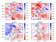
This data set consists of multi-scale and high-resolution seismic wave velocity, attenuation, anisotropy, interface and stress field model of the crust, lithosphere and upper mantle beneath the Sichuan-Yunnan area. The velocity and attenuation models are mainly obtained by applying waveform adjoint tomography, double difference tomography and ambient noise tomography methods. The anisotropic models are mainly obtained by applying shear wave splitting, receiver functions and ambient noise methods. The interface structure is mainly obtained by receiver functions. The stress field model is mainly restrained by GPS velocity field and focal mechanism. Some of the used seismic waveform are from published data, and some are obtained from deployed seismic stations. The model data set can be used for further study on valuable scientific issues such as the mechanism of the occurrence of large earthquakes and the tectonic evolution of the lithosphere beneath the Chuandian Block, and the dynamic mechanism of the eastward extrusion of the Tibetan Plateau.
PEI Shunping

The data set is the dispersion curves results of seismic stations in Sichuan-Yunnan region obtained by using ambient noise and teleseismic surface waveforms. First, the seismic waveform data is collected from seismic stations deployed in the Sichuan-Yunnan region. Using the collected seismic waveform data, we intercept waveform of each day from each station. After removing the mean and trend and filtering, we invert the dispersion curves of seismic stations in Sichuan-Yunnan region by using the ambient noise and teleseismic surface waveforms based on time-frequency analysis. The model can be used for further study on valuable scientific issues such as the mechanism of the large earthquakes preparation, tectonic evolution of the lithosphere in Sichuan-Yunnan region and the eastward extrusion of the Tibetan Plateau.
AI Yinshuang
Contact Support
Links
National Tibetan Plateau Data CenterFollow Us

A Big Earth Data Platform for Three Poles © 2018-2020 No.05000491 | All Rights Reserved
|  No.11010502040845
Tech Support: westdc.cn