Recently, Prof. ZHOU Ji (corresponding author) and Dr. ZHANG Xiaodong (first author) from the School of Resources and Environment, Center for Information Geoscience, University of Electronic Science and Technology of China published an article in Remote Sensing of Environment (IF =10.164) entitled "A practical reanalysis data and thermal infrared remote sensing data merging (RTM) method for reconstruction of a 1-km all-weather land surface temperature". The corresponding data "Daily 1-km all-weather land surface temperature dataset for Western China (TRIMS LST-TP; 2000-2020) V2" is published in the National Tibetan Plateau/Third Pole Environment Data Center (http://data.tpdc.ac.cn/en/) and is available for open access.
Land Surface Temperature (LST) plays a pivotal role in driving the matter cycles as well as energy interactions at the earth-atmosphere boundary. It is not only a sensitive indicator of climate change and an important prerequisite for grasping climate change patterns, but also a direct input parameter for many models, and has a wide range of applications in many fields. Along with the deepening and refinement of research in geology and related fields, and in the context of the Second Tibetan Plateau Scientific Expedition program, all-weather LST, which is reconstructed and inverted by satellite remote sensing, is facing an urgent demand. To this end, Prof. ZHOU Ji 's group has developed the dataset "Daily 1-km all-weather land surface temperature dataset for Western China (TRIMS LST-TP; 2000-2020) V2" after years of research.
Based on the temporal component decomposition model of LST, this study proposes a novel and practical reanalysis and thermal infrared remote sensing data merging (RTM) method to reconstruct a 1-km all-weather LST. The method is at first applied to merge Aqua MODIS LST and GLDAS LST over the Tibetan Plateau and the merged LST is validated against the ground measurements. Then the method is applied to merge Terra MODIS LST and CLDAS LST for further inter-comparison with the ESTARM-based method. The temporal resolution of this dataset is 2 times per day, the spatial resolution is 1 km, and the spatial coverage includes the Tibetan Plateau and the surrounding areas; the time span is 2000-2020 (note: the all-weather surface temperature in the missing time period of Aqua MODIS LST product is completed by extrapolation). Figure 1 shows the spatial distribution of daytime and nighttime TRIMS LST-TP for day 181 of 2000.
Using the same method as the TRIMS LST-TP dataset, Prof. ZHOU Ji's group also prepared the "Daily 1-km all-weather land surface temperature dataset for the Chinese landmass and its surrounding areas (TRIMS LST; 2000-2020)". This dataset is also published simultaneously at the National Tibetan Plateau/Third Pole Environment Data Center to meet the application needs of other regions.
This work was supported by the National Natural Science Foundation of China (grant no. 41871241), National Key Project of China (grant nos. 2018YFC1505205), and by the Fundamental Research Funds for the Central Universities of China, University of Electronic Science and Technology of China under Grant ZYGX2019J069. This work was also supported by the ESA-MOST Dragon 5 Cooperation Programme under Grant 59318.
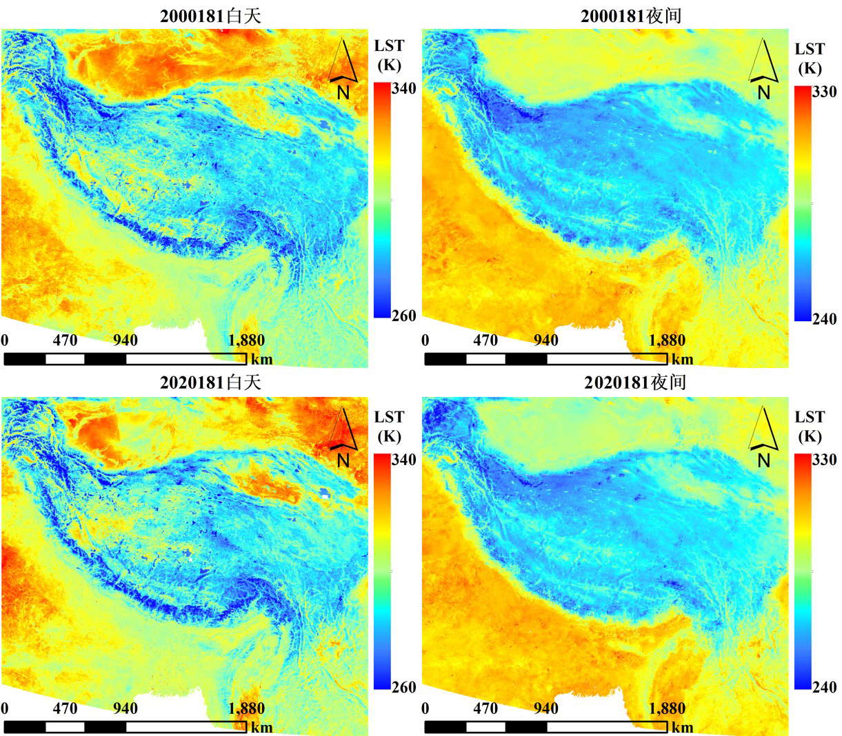
Figure 1. spatial distribution of daytime and nighttime TRIMS LST-TP for day 181 of 2000.
Article:
Zhang, X., Zhou, J., Liang, S., Wang, D. (2021). A practical reanalysis data and thermal infrared remote sensing data merging (RTM) method for reconstruction of a 1-km all-weather land surface temperature. Remote Sensing of Environment, 260, 112437. https://doi.org/10.1016/j.rse.2021.112437.
Data available at:
1. Daily 1-km all-weather land surface temperature dataset for Western China (TRIMS LST-TP; 2000-2020) V2:
http://data.tpdc.ac.cn/zh-hans/data/d09ebfe3-a8c9-49b5-aa22-1fd484751d70/
(doi: 10.11888/Meteoro.tpdc.270953)
2. Daily 1-km all-weather land surface temperature dataset for the Chinese landmass and its surrounding areas (TRIMS LST; 2000-2020):
http://data.tpdc.ac.cn/zh-hans/data/05d6e569-6d4b-43c0-96aa-5584484259f0/
(doi: 10.11888/Meteoro.tpdc.271252)
Contact Support
Links
National Tibetan Plateau Data CenterFollow Us

A Big Earth Data Platform for Three Poles © 2018-2020 No.05000491 | All Rights Reserved
|  No.11010502040845
Tech Support: westdc.cn

